Lewiston Levee Parkway and Clarkston Greenbelt Trail
Distance
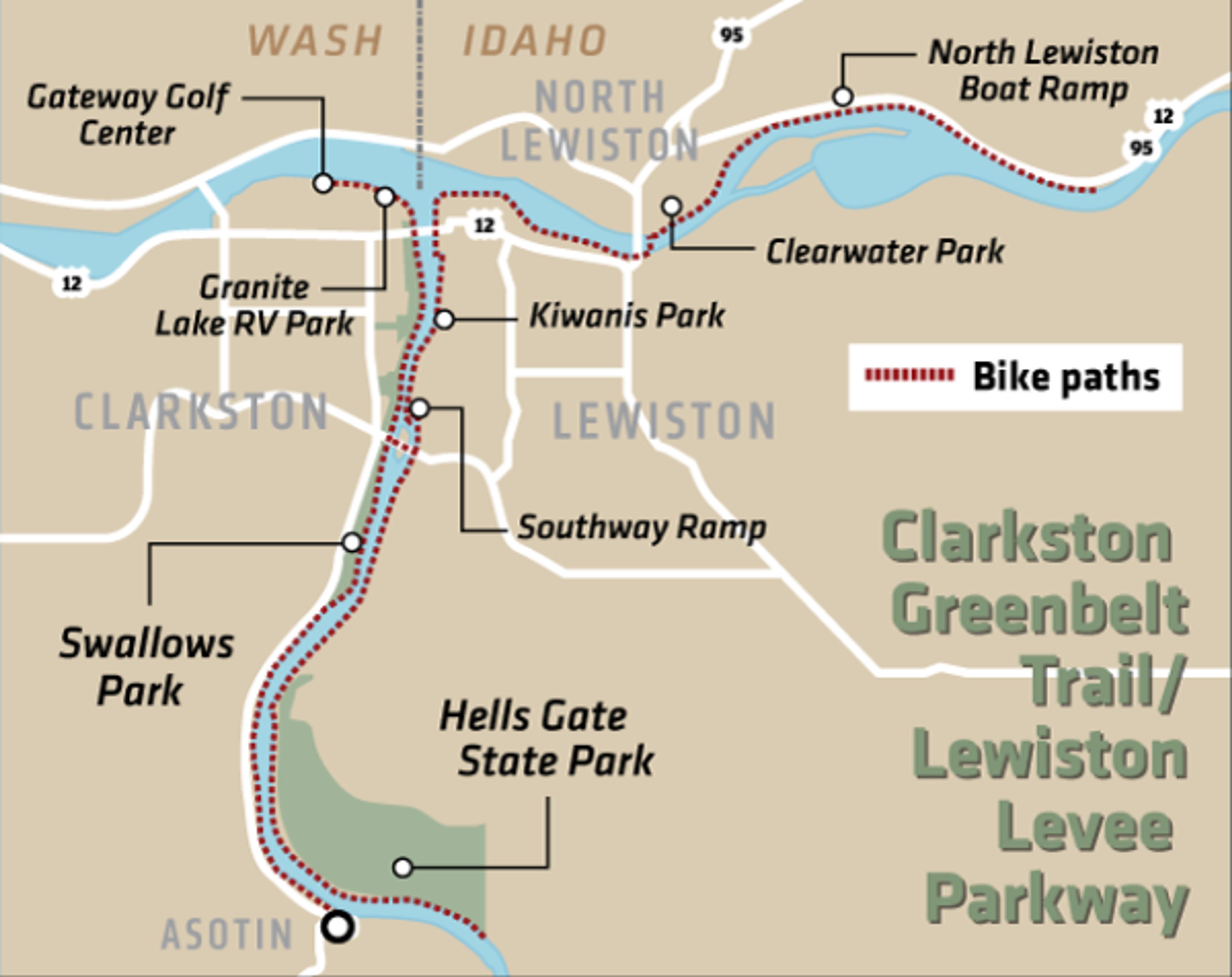
18.9 miles of pathway. Lewiston: 6.4 miles from Hells Gate Parking Lot to Memorial Bridge over the Clearwater River. Clarkston: 6.2 miles from the Greenbelt Boat Ramp parking lot to Chief Looking Glass Park in Asotin
Difficulty
Easy. Smooth, flat paved path with occasional small hills.
Access
Park at any of the several lots along the trail. Large, paved parking lots are at Chief Looking Glass Park in Asotin; Swallows Park and the Greenbelt Boat Ramp lot in Clarkston; and Kiwanis Park, Southway Boat Ramp, Hells Gate State Park and along the Levee Bypass in Lewiston.
Trail features
The wide, smoothly paved pathways provide recreational access on both sides of the Snake River. Restrooms and drinking water are along the path, in addition to playgrounds, picnic tables, benches and swimming beaches. It is not uncommon to see people fishing from the riverbank.
The Lewiston side features two interpretive centers: one describes the historic journey of Lewis and Clark and the other, river navigation. Besides these built-in features, watch for wildlife: yellow-bellied marmots, gulls, geese and ducks are common.
Trail tips
Trails get the highest traffic on warm spring weekends, so ride slow and keep an eye out for pedestrians, cyclists, children and pets - especially those on long leashes. The pathway speed limit is 15 mph. No motorized bicycles are allowed.
The Clarkston greenbelt between the Interstate and Southway bridges gets high use because of the shade it provides, along with grassy play areas. On the Lewiston side, the pathway from Kiwanis Park to the Clearwater Landing sees the highest traffic. All three bridges have pedestrian/cycling paths for crossing, though the crossing over the Interstate Bridge is narrow and requires climbing a few stairs.
The Lewiston pathway continues through Locomotive Park and over Memorial Bridge, though the route is not well-marked. After crossing the bridge, the path turns to the left from the road and continues along the Clearwater River for nearly five miles until it meets Highway 12.
The Clarkston trail continues past the Army Corps of Engineers parking lot to the Port of Clarkston.
The Corps is always working on updates to the pathway, including the addition of mileage markers. Maps and other information are available at the Lower Granite Natural Resources Management Section at 100 Fair St. in Clarkston.
- Michelle Schmidt


